Background
One of today’s most pressing challenges is to safeguard the loss of ecosystem biodiversity and functioning, while simultaneously allowing for their exploitation by those who depend on their services, goods and benefits. In Europe, Maritime Spatial Planning (MSP) is the main governance process to ideally integrate sustainability and exploitation. This requires tools and knowledge to align MSP and marine protected area (MPA) designation processes, which are lacking particularly regarding transboundary coordination and connectivity.
Main Goal
Founded on a large amount of expertise and a solid theoretical basis, MarinePlan will co-develop with stakeholders and apply a Decision Support System (DSS) for ecosystem-based maritime spatial planning (EB-MSP) together with best practice guidance to enhance the design and effectiveness of spatial conservation and restoration measures for marine biodiversity in European Seas.
Tools will comprise operational criteria for ecologically or biologically significant marine areas (EBSA), enabling the allocation of conservation and restoration areas at various scales in complex sea areas with multiple uses, while including the effects of climate change.
Objectives
The above stated main goal will be achieved through four specific objectives for the European seas:
#1 Co-develop with stakeholders the conceptual elements of the DSS (guidelines and tools) and derive best practice guidance for EB-MSP implementation
#2 Develop quantitative metrics to operationalise ecological or biological significance and their application at various spatiotemporal scales
#3 Implement and apply the DSS based on objectives #1 and #2, its guidelines, metrics and tools at Planning Sites representing the diversity of European marine areas
#4 Provide recommendations and improvements in relation to the shortcomings, impediments to and opportunities of prevailing governance processes to enhance the implementation of EB- MSP
Approach
MarinePlan develops and applies the EB-MSP DSS within seven Work Packages and eight European Planning Sites. The Planning Sites range from coastal ecosystems to open ocean and the deep sea and from local to trans-boundary scales. Applying and validating the DSS incorporates realistic planning scenarios, key action points to achieve the EU Biodiversity Strategy, and policy recommendations how to enhance EB-MSP implementation in European Seas. MarinePlan will communicate results to decision-makers at horizontal (between sectors) and vertical (from local to European) levels and enable the transfer of knowledge to areas in differing socio-ecological settings. The improved natural and social science base will ensure effective policymaking to support a greater coherence in implementing environmental policies as well as to enable streamlined planning for marine industries.
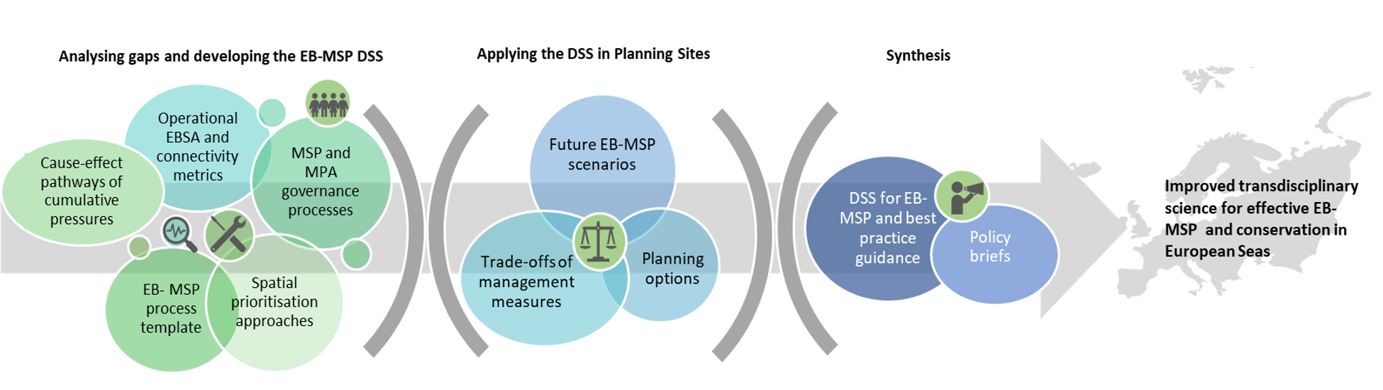
Expected main outputs
- a comprehensive DSS comprising guidelines and tools for EB-MSP implementation together with best practice guidance;
- operational EBSA criteria and proposed MPA networks at various scales based on the best available science;
- examples of realistic scenarios and planning options prioritising conservation and restoration areas in the context of multiple human uses and climate change and a synthesis of key action points to achieve the EU Biodiversity Strategy, and
- policy recommendations on how to enhance the implementation of EB-MSP in European Seas.
Accordingly, these outputs encompass concepts, tools (software, scripts, code), reports, fact sheets and policy briefs, as well as Open Access peer-reviewed published papers.

This project has received funding from the European Union's Horizon Europe research and innovation programme HORIZON-CL6-2021-BIODIV-01-12 under grant agreement No 101059407 and by UK Research and Innovation (UKRI) under the UK government’s Horizon Europe funding guarantee grant numbers 10038951 & 10050537. Views and opinions expressed are however those of the authors only and do not necessarily reflect those of the European Union or UK Research and Innovation. Neither the European Union nor the granting authority can be held responsible for them.